Ecoregions of North America
Level I EcoregionsLevel II Ecoregions
Level III Ecoregions
Download maps and descriptions
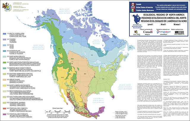
Viewing the ecological hierarchy at this scale provides a context for seeing global or intercontinental patterns. Level I ecological regions are: Arctic Cordillera, Tundra, Taiga, Hudson Plains, Northern Forests, Northwestern Forested Mountains, Marine West Coast Forests, Eastern Temperate Forests, Great Plains, North American Deserts, Mediterranean California, Southern Semi-Arid Highlands, Temperate Sierras, Tropical Dry Forests and Tropical Wet Forests.
Brief narrative descriptions of each level I region can be found in Section III of the Commission for Environmental Cooperation's publication "Ecological Regions of North America--Toward a Common Perspective" (CEC 1997). These descriptions—each of which is divided into sections describing the physical setting, biological setting and human activities therein—provide an overview of the principal attributes of each region. The intent is to provide a sense of the ecological diversity, the human interactions taking place and how each region differs from adjacent ones.
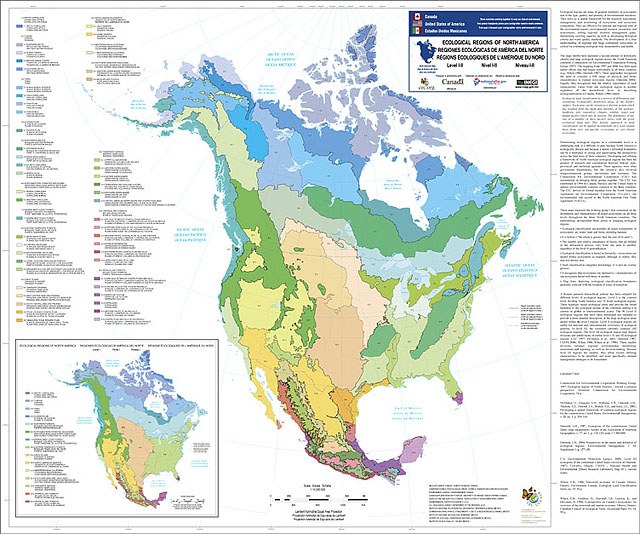
Level II: The 50 level II ecological regions that have been delineated are intended to provide a more detailed description of the large ecological areas nested within the level I regions. For example, the Tropical Wet Forests of level I is the region covering coastal portions of the United States and Mexico, and is composed of six level II regions. Level II ecological regions are useful for national and subcontinental overviews of ecological patterns. Three level I regions (Hudson Plains, Marine West Coast Forest, and Mediterranean California) have no subdivisions at level II. The Temperate Sierras, Tropical Dry Forests, and Tropical Wet Forests level I regions, on the other hand, each have six level II subdivisions.
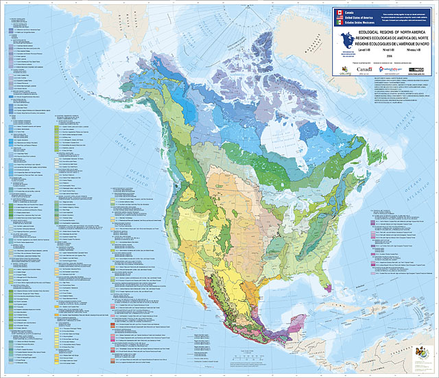
Level III: Level III mapping describes smaller ecological areas nested within level II regions. At level III, the continent currently contains 182 ecological regions. These smaller divisions enhance regional environmental monitoring, assessment and reporting, as well as decision-making. Because level III regions are smaller, they allow locally defining characteristics to be identified, and more specifically oriented management strategies to be formulated (CEC 1997).
For more information on the maps above, visit the Commission for Environmental Cooperation (CEC) Ecological Regions of North America.
- Level I Ecoregions:
- Ecoregions of North America (contains level I, II, and III):
- Level I Ecoregions of North America Shapefile (28 mb)
- Level I Ecoregions of North America Metadata and Level I Ecoregions of North America Symbology
- Level II Ecoregions of North America Shapefile (30 mb)
- Level II Ecoregions of North America Metadata and Level II Ecoregions of North America Symbology
- Level III Ecoregions of North America Shapefile (34 mb)
- Level III Ecoregions of North America Metadata and Level III Ecoregions of North America Symbology
- Instructions for applying symbology to ecoregions
Ecoregion Links
Ecoregion Home |
Level I |
Level II |
Level III |
Level IV |
Publications |
Download Site |
Links |
Contacts