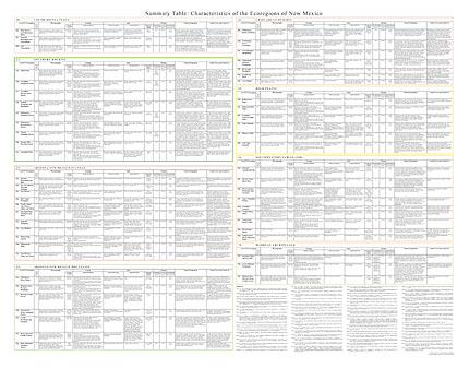
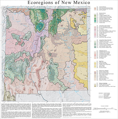
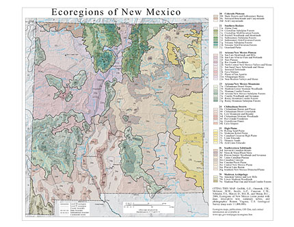
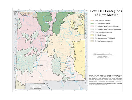
The approach used to compile this map is based on the premise that ecological regions can be identified through the analysis of the spatial patterns and the composition of biotic and abiotic phenomena that affect or reflect differences in ecosystem quality and integrity (Wiken, 1986; Omernik, 1987, 1995). These phenomena include geology, physiography, vegetation, climate, soils, land use, wildlife, and hydrology. The relative importance of each characteristic varies from one ecological region to another regardless of the hierarchical level. A Roman numeral hierarchical scheme has been adopted for different levels of ecological regions. Level I is the coarsest level, dividing North America into 15 ecological regions. Level II divides the continent into 52 regions (Commission for Environmental Cooperation Working Group, 1997). At level III, the continental United States contains 104 ecoregions and the conterminous United States has 84 ecoregions (United States Environmental Protection Agency [USEPA], 2003). Level IV is a further subdivision of level III ecoregions. Explanations of the methods used to define the USEPA’s ecoregions are given in Omernik (1995), Omernik and others (2000), Griffith and others (1994), and Gallant and others (1989). New Mexico contains semiarid shrub- and grass-covered plains, forested mountains, glaciated peaks, woodland- and shrubland-covered hills, lava fields and volcanic plateaus, river floodplains, and arid deserts. Ecological diversity is enormous. There are 8 level III ecoregions and 55 level IV ecoregions in New Mexico and many continue into ecologically similar parts of adjacent states (Griffith and others, 2004; Woods and others, 2005; Chapman and others, 2006). This poster is part of a collaborative project primarily between USEPA Region VI, USEPA National Health and Environmental Effects Research Laboratory (Corvallis, Oregon), New Mexico Environment Department (NMED), U.S. Department of Agriculture (USDA)–Natural Resources Conservation Service (NRCS), and U.S. Geological Survey (USGS)–National Center for Earth Resources Observation and Science (EROS). The project is associated with an interagency effort to develop a common framework of ecological regions (McMahon and others, 2001). Reaching that objective requires recognition of the differences in the conceptual approaches and mapping methodologies applied to develop the most common ecoregion-type frameworks, including those developed by the USDA–Forest Service (Bailey and others, 1994), the USEPA (Omernik, 1987, 1995), and the NRCS (U.S. Department of Agriculture–Soil Conservation Service, 1981). As each of these frameworks is further refined, their differences are becoming less discernible. Collaborative ecoregion projects, such as this one in New Mexico, are a step toward attaining consensus and consistency in ecoregion frameworks for the entire nation. Bailey, R.G., Avers, P.E., King, T., and McNab, W.H., eds., 1994, Ecoregions and subregions of the United States (map) (supplementary table of map unit descriptions compiled and edited by McNab, W.H. and Bailey, R.G.): Washington, D.C., USDA–Forest Service, scale 1:7,500,000. Bryce, S.A., Omernik, J.M., and Larsen, D.P., 1999, Ecoregions – a geographic framework to guide risk characterization and ecosystem management: Environmental Practice, v. 1, no. 3, p. 141-155. Chapman, S.S., Griffith, G.E., Omernik, J.M., Price, A.B., Freeouf, J., and Schrupp, D.L., 2006, Ecoregions of Colorado: Reston, Virginia, U.S. Geological Survey, map scale 1:1,200,000. Commission for Environmental Cooperation Working Group, 1997, Ecological regions of North America – toward a common perspective: Montreal, Commission for Environmental Cooperation, 71 p. Gallant, A.L., Whittier, T.R., Larsen, D.P., Omernik, J.M., and Hughes, R.M., 1989, Regionalization as a tool for managing environmental resources: Corvallis, Oregon, U.S. Environmental Protection Agency, EPA/600/3-89/060, 152 p. Griffith, G.E., Bryce, S.A., Omernik, J.M., Comstock, J.A., Rogers, A.C., Harrison, B., Greenwade, J., Casby-Horton, S., Hatch, S.L., and Bezanson, D., 2004, Ecoregions of Texas: Reston, Virginia, U.S. Geological Survey, map scale 1:2,500,000. McMahon, G., Gregonis, S.M., Waltman, S.W., Omernik, J.M., Thorson, T.D., Freeouf, J.A., Rorick, A.H., and Keys, J.E., 2001, Developing a spatial framework of common ecological regions for the conterminous United States: Environmental Management, v. 28, no. 3, p. 293-316. Omernik, J.M., 1987, Ecoregions of the conterminous United States (map supplement): Annals of the Association of American Geographers, v. 77, no. 1, p. 118-125, scale 1:7,500,000. Omernik, J.M., 1995, Ecoregions – a framework for environmental management, in Davis, W.S. and Simon, T.P., eds., Biological assessment and criteria-tools for water resource planning and decision making: Boca Raton, Florida, Lewis Publishers, p. 49-62. Omernik, J.M., 2004, Perspectives on the nature and definition of ecological regions: Environmental Management, v. 34, Supplement 1, p. s27-s38. Omernik, J.M., Chapman, S.S., Lillie, R.A., and Dumke, R.T., 2000, Ecoregions of Wisconsin: Transactions of the Wisconsin Academy of Sciences, Arts, and Letters, v. 88, p. 77-103. U.S. Department of Agriculture–Soil Conservation Service, 1981, Land resource regions and major land resource areas of the United States: Agriculture Handbook 296, 156 p. U.S. Environmental Protection Agency, 2006, Level III ecoregions of the continental United States (revision of Omernik, 1987): Corvallis, Oregon, USEPA – National Health and Environmental Effects Research Laboratory, Map M-1, various scales. Wiken, E., 1986, Terrestrial ecozones of Canada: Ottawa, Environment Canada, Ecological Land Classification Series no. 19, 26 p. Woods, A.J., Omernik, J.M., Butler, D.R., Ford, J.G., Henley, J.E., Hoagland, B.W., Arndt, D.S., and Moran, B.C., 2005, Ecoregions of Oklahoma: Reston, Virginia, U.S. Geological Survey, map scale 1:1,250,000. PRINCIPAL AUTHORS: Glenn E. Griffith (Dynamac Corporation), James M. Omernik (USGS), Maryann M. McGraw (NMED), Gerald Z. Jacobi (Jacobi and Associates), Christopher M. Canavan (NMED), T. Scott Schrader (NMSU), David Mercer (NMED), Robert Hill (NRCS), and Brian C. Moran (Indus Corporation). COLLABORATORS AND CONTRIBUTORS: Shann Stringer (NMED), David McCraw (NM Bureau of Geology and Mineral Resources), Ken Scheffe (NRCS), Paul Neville (EDAC/UNM), Phil Crocker (USEPA), Shannen Chapman (Dynamac Corporation), Sandy Bryce (Dynamac Corporation), Mark Gruber (New Mexico Department of Game and Fish), John Hutchinson (Science Applications International Corporation), Jack Wittmann (USGS), and Tom Loveland (USGS).
Ecoregion Links |